
City of Brea
Planning Commission Communication
A. Project Introduction - Greenbriar Residential Development at 1698-1700 Greenbriar Lane
Meeting
Tuesday, February 25, 2025, 6:00 PM
Agenda Group
ADMINISTRATIVE ITEMS Item: 3A.
EXECUTIVE SUMMARY
The Applicant, Lennar Homes of California, Inc., has submitted planning entitlements for a project that would demolish an existing 164,908 square foot office building, a three-level parking structure, and surface parking and associated landscape areas, and construct a residential development consisting of 179 single-family units (detached and attached) with a private recreational area, on a 9.7-acre property located at 1698-1700 Greenbriar Lane. The entitlements necessary to facilitate the proposed project are as follows:
- Environmental Impact Report (EIR) No. 2024-01: to analyze the environmental impacts resulting from construction and operation of the proposed project, which is prepared pursuant to the California Environmental Quality Act (CEQA) and CEQA Guidelines;
- Vesting Tentative Tract Map (TTM) No. 2024-01: to allow for a condominium map;
- General Plan Amendment (GPA) No. 2024-02: to modify the project site’s General Plan land use designation from General Commercial to a Mixed-Use II land use designation;
- Zone Change (ZC) No. 2024-02: to modify the project site from C-G General Commercial Zone to a Mixed-Use II (MU-II) Zone;
- Development Agreement (DA) No. 2024-01: for a contract between the Applicant and the City, defining terms of development proposed by vesting the City’s approval while specifying public benefits; and
- Precise Development (PD) No. 2024-2: to demolish an existing 164,908 square foot office building, a three-level parking structure, and surface parking and associated landscape areas, and construct a residential development consisting of 179 single-family units (detached and attached) with a private recreational area.
The above-mentioned entitlements herein are referred to as the "Project."
RECOMMENDATION
Staff recommends that the Planning Commission take the following actions:
- Receive Project information from staff and the Project Applicant; and
- Provide Project related feedback to staff, if any.
BACKGROUND
Project Location
The Project site, located at 1698-1700 Greenbriar Lane, is a 9.7-acre property that is situated west of South Associated Road, south of Greenbriar Lane, and north of the Brea Plaza Shopping Center. The Project site is currently developed with a 164,908 square foot office building, a three-level parking structure, and surface parking and associated landscape areas, and was most recently occupied by Mercury Insurance. Vehicle access to the Project site is currently provided by one driveway approach on Greenbriar Lane and an internal access road that connects the Project site to the Brea Plaza Shopping Center along the southern property line. The Project site has a General Plan Land Use designation of General Commercial and a zoning designation of C-G General Commercial. The Project Vicinity Map, the surrounding land uses and zoning designations are shown in Figure 1 and Tables 1 and 2 below.
Figure 1. Project Vicinity Map
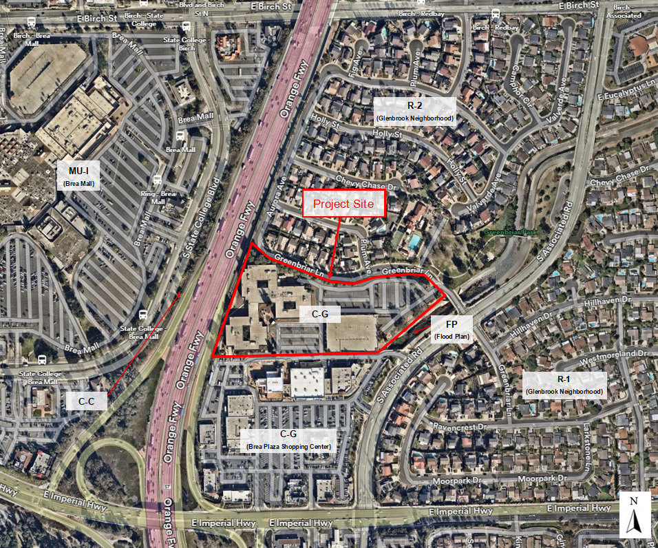
TABLE 1 – Surrounding Land Uses
|
North |
Single-family residential uses |
|
East |
Single-family residential uses (across the Fullerton Creek drainage channel & S. Associated Road) |
|
South |
Brea Plaza Shopping Center |
|
West |
Brea Mall (across State Route SR-57 & State College Avenue) |
TABLE 2 – Surrounding Zoning Designations
|
North |
Multiple Family Residential (R-2) |
|
East |
Single-Family Residential (R-1) (across the Fullerton Creek drainage channel & S. Associated Road) |
|
South |
General Commercial (C-G) |
|
West |
Regional Commercial (C-C) and Mixed-Use I (MU-I) (across State Route SR-57 & State College Avenue) |
Entitlement History
- In 1975, the existing 164,908 square foot office building was approved under Precise Development (PD No. 19-75) and Parcel Map (PM No. 3-75) as part of the Brea Plaza Office Park, which included the Project site and the site that is now occupied by the Brea Plaza Shopping Center.
- In 2005, the construction of the three-level parking structure was approved under Conditional Use Permit (CUP No. 05-02), Precise Development (PD No. 05-01), and Mitigated Negative Declaration (ND No. 05-01).
- Private agreement: The Project site and Brea Plaza Shopping Center are currently under an existing memorandum of understanding (MOU) that allows customers of the Brea Plaza Shopping Center to use approximately 180 parking spaces located at the Project site during normal business hours, and all of the surface parking spaces (approximately 500 spaces) after 5:00 p.m. and on weekends. The MOU expires in April 2026, unless voluntarily terminated by both parties sooner.
PROJECT DESCRIPTION
The Applicant proposes to demolish an existing 164,908 square foot office building, a three-level parking structure, and surface parking and associated landscape areas, and construct a residential development consisting of 179 single-family units (detached and attached) including landscaping and common open space areas, which would include a private park.
General Plan Amendment and Zone Change
To accommodate the 179-unit residential development, the Project would require a General Plan Amendment to modify the site’s General Plan land use designation from General Commercial to Mixed-Use II as well as a Zone Change to modify the zoning designation from C-G General Commercial Zone to a Mixed-Use II (MU-II) Zone.
Site Plan and Circulation
The Project layout proposes a row of buildings along the northern, eastern, and southern property lines as well as smaller vertical rows of buildings towards the center of the development. The site would be accessed via two new vehicular connections along Greenbriar Lane (one at the eastern end and one at the western end of the Project site). Per the City’s roadway standards, Greenbriar Lane would be reconfigured and the two new internal access roads would connect at “t-intersections” to accommodate the Project. Additionally, the existing internal access road that connects the Project site and the Brea Plaza Shopping Center would be closed. However, the existing pedestrian accessway connecting the Project site and the Brea Plaza Shopping Center, located at the southeast corner of the Project site, would remain. To accommodate the proposed residential development, the Project includes a Tentative Tract Map for condominium purposes.
The Project would include eight internal streets (A through H Drive) and 11 cul-de-sacs (I through J Court and L through T Court). Attachment A is the Project’s Tentative Tract Map, and Figure 2 below illustrates the proposed Project Layout (Attachment B – Illustrative Site Plan).
Figure 2. Proposed Project Layout
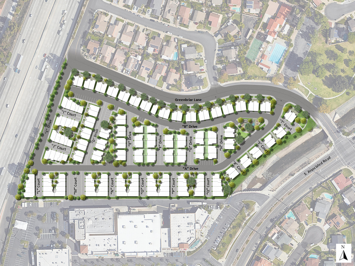
Building Types
The Project would include 67 buildings consisting of three different housing products. Table 3 below provides a breakdown of the proposed building and unit summary, and the below narrative provides descriptions of each housing product:
TABLE 3 – Proposed Building & Unit Summary
|
Housing Product |
Number of Buildings |
Number of Units |
|
The Courts |
16 |
80 |
|
The Villas |
37 |
73 |
|
The Yards |
14 |
26 |
|
Residential Subtotal |
67 |
179 |
- The Courts: The Courts would consist of a total of 16 three-story buildings (80 units), which would be either 36’-9” or 36’-11” in height. The majority of the Courts buildings would be oriented in a “U” shape to provide an internal garden courtyard for residents. The floor plans would range in size from approximately 964 to 1,946 square feet and would provide one-, two-, three-, and four-bedroom units. Each unit would have an enclosed two-car garage, except the one-bedroom units, which would have an enclosed one-car garage.
- The Villas: The Villas would consist of a total of 37 four-story buildings (73 units) and would include a rooftop terrace on the fourth floor (48’-11’’ or 44’-2’’ in height, depending on style option). The majority of the Villas buildings would be attached duplexes, which the exception of one stand-alone unit. The floor plans would range in size from approximately 2,294 to 2,503 square feet and would provide three- and four-bedroom units. Each unit would have an enclosed two-car garage.
- The Yards: The Yards would consist of a total of 14 three-story buildings (26 units), which would be 41’-5’’ or 35’-7’’ in height, depending on style option. The majority of the Yards buildings would be attached duplexes, which the exception of two stand-alone units. The floor plans would range in size from approximately 1,846 to 2,450 square feet and would provide three-bedroom units. Each unit would have an enclosed two-car garage.
The Floors Plans and Elevation Drawings are provided as Attachment C.
Building Design
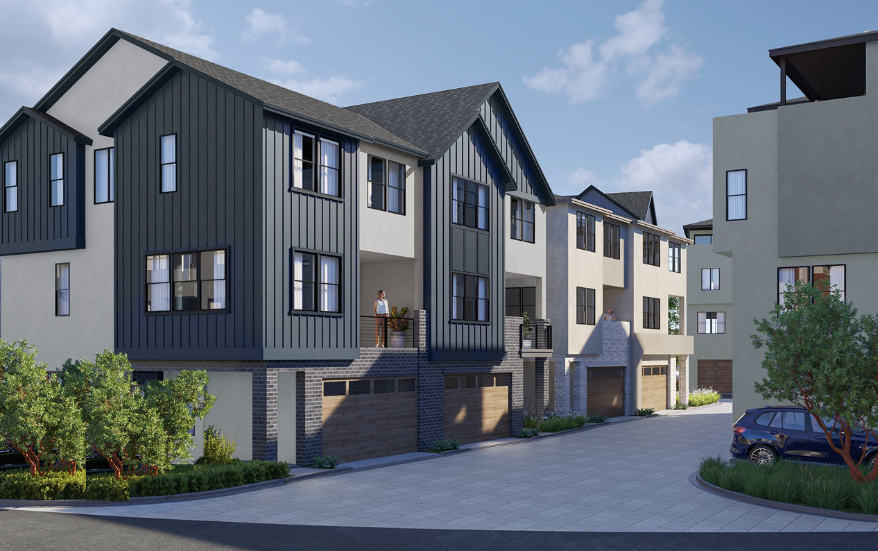
The proposed building designs includes a mixture of farmhouse and contemporary architecture that would be complimentary to one another and the surrounding areas. The elevations of the proposed housing products utilize color schemes involving white, beige and gray with accent tones in black and brown, along with varying materials such as stone, brick, and wood planks, as shown in Figures 3, 4, and 5 below.
Figure 3. Proposed Building Renderings – The Courts
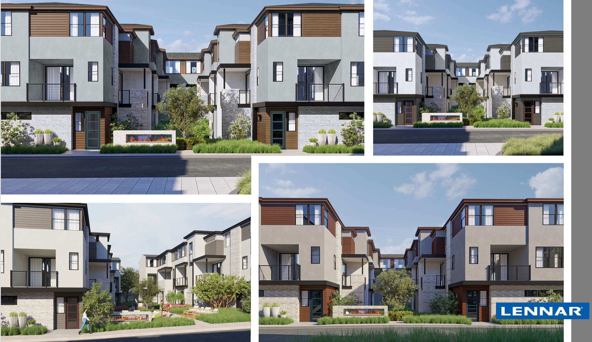
Figure 4. Proposed Building Renderings – The Villas
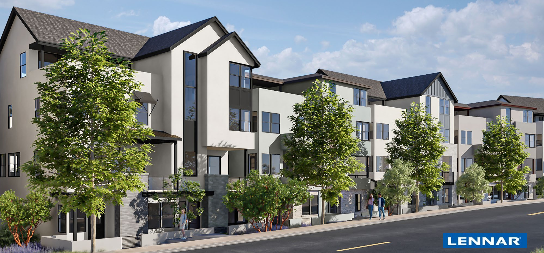

Figure 5. Proposed Building Renderings – The Yards
Development Standards
The Project complies with a majority of the development standards established for the MU-II zoning district. Table 4 below provides a breakdown of the Project’s zoning conformance:
TABLE 4 – Compliance with Development Standards
|
Development Standard |
Zoning Code Standards (min./max.) |
Proposed |
|
Minimum Project Size |
2,500 sq. ft. |
422,478 sq. ft. (approximately 9.7 acres) |
|
Density |
6.1 to 40 du/ac |
18.4 units per acre |
|
Floor Area Ratio (FAR) |
2.00 |
1.20 |
|
Height |
60 ft. |
The Courts – 36’-11’’ for the five-unit buildings & 36’-9’’ for the 10-unit buildings The Villas – 44’-2’’ or 48’-11’’, depending on style option The Yards – 35’-7’’ or 41’-5’’, depending on style option |
|
Building Setbacks Front (S. Associated Road) Street Side (Greenbriar Lane) Interior Side Rear (State Route SR-57) |
15 ft. 15 ft. 10 ft. 20 ft. |
155’-7’’ *12’-3’’ to 23’-4’’ 10’ *16’-7’’ to 61’-9’’ |
|
Landscape Setbacks Front (S. Associated Road) Street Side (Greenbriar Lane) Interior Side Rear (State Route SR-57) |
Front: 8 ft. Street Side: 8 ft. Interior Side: 5 ft. Rear: 5 ft. |
29’-9’’ 12’-3’’ to 23’-4’’ 10’ 5’-8’’ |
|
Common Open Space |
100 sq. ft. per unit (Minimum dimension shall be 15 feet.) |
Approximately 39,995 sq. ft. |
|
Private Open Space |
75 sq. ft. per unit (Minimum dimension shall be 8’ feet) |
Ranges in size from approximately 96 sq. ft. to 347 sq. Ft. (balconies, roof top deck, private courtyards) |
|
Parking |
448 (358 garage spaces; 90 guest spaces) |
*397 (342 garage spaces; 55 guest spaces) |
|
*The project would either have to meet the standards or obtain approval of Minor Conditional Use Permit (MCUP) to modify the required minimum development standard. |
||
As shown on Table 4 above, there are three development standards that are not being met (i.e. minimum street side setback, minimum rear setback, minimum parking requirements). As such, the Applicant would either be required to update the Project plans to comply with the applicable development and/or obtain subsequent approval of a MCUP or any other available administrative permit for the requested modification of standards.
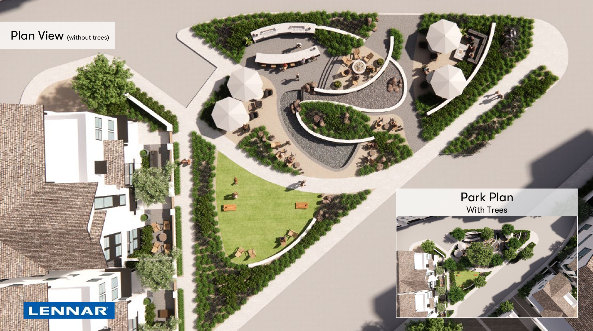
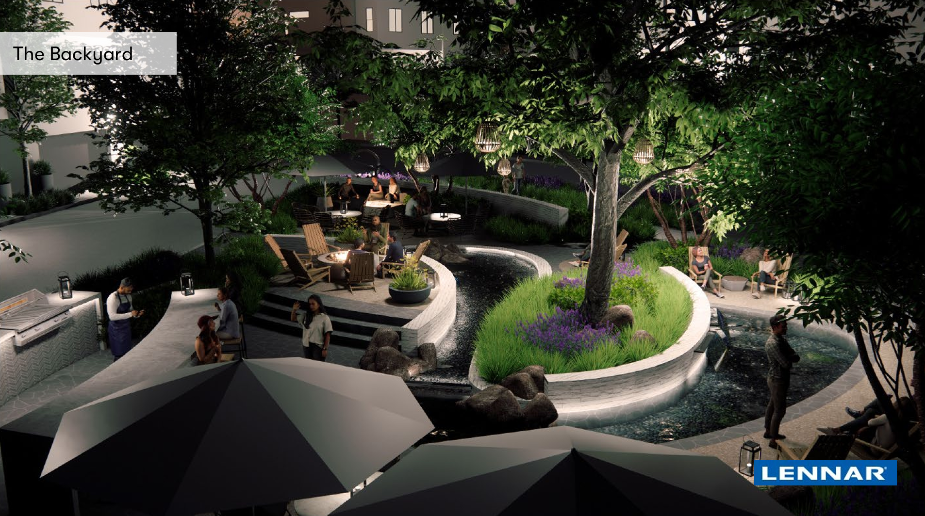
Landscaping and Open Space
The Project would provide 104,785 square feet of ornamental landscaping throughout the site, including both parameter and internal landscaping areas, and 35,423 square feet of common hardscape areas. The Project would be required to comply with the minimum landscaping requirement standards. In addition, the proposed landscaping area would include a 7,569 square-foot private park. A conceptual park plan is shown on Figure 6 below.
Figure 6. Conceptual Park Plan
Parking
The Project provides a total of 397 parking spaces, of which 342 spaces are enclosed garage spaces and 55 spaces are exterior guest parking spaces. The 55 guest parking spaces would be located throughout the Project site and would include four accessible parking spaces and six electric vehicle charging spaces. The guest parking areas would be screened by landscape hedges or retaining walls, or a combination thereof. No on-street or driveway parking is provided as part of the proposal.
As previously mentioned in the Development Standards section of this report, the minimum required parking per BCC is a total of 448 off-street parking spaces (358 enclosed garages and 90 guest parking spaces). As such, the Project would be required to obtain an approval of a MCUP to allow a reduction in the number of required parking spaces as allowed by BCC Section 20.408.030.B.2.a.2, or any other available administrative permit.
Construction Phasing
If approved, construction activities (e.g. demolition, rough grading, infrastructure and offsite improvements, building construction, etc.) are anticipated to commence in April 2026. The construction is estimated to take approximately 31 months, with the anticipated completion date in late 2028.
Development Agreement
The Project requires a DA to define the terms of the proposed development by vesting the City’s approval while specifying public benefits and improvements. Additionally, the Applicant as indicated that they intend to satisfy the City’s affordable housing requirements either by: 1) providing affordable housing on-site consistent with State Density Bonus Law; 2) providing land to the City for the construction of affordable units by the City; or 3) providing affordable housing at an off-site location.
REQUIRED ENTITLEMENTS
The Project requires the following entitlements:
- Environmental Impact Report (EIR) No. 2024-01: to analyze the environmental impacts resulting from construction and operation of the proposed project, which is prepared pursuant to the California Environmental Quality Act (CEQA) and CEQA Guidelines;
- Vesting Tentative Tract Map (TTM) No. 2024-01: to allow for a condominium map;
- General Plan Amendment (GPA) No. 2024-02: to modify the project site’s General Plan land use designation from General Commercial to a Mixed-Use II land use designation;
- Zone Change (ZC) No. 2024-02: to modify the project site from C-G General Commercial Zone to a Mixed-Use II (MU-II) Zone;
- Development Agreement (DA) No. 2024-01: for a contract between the Applicant and the City, defining terms of development proposed by vesting the City’s approval while specifying public benefits; and
- Precise Development (PD) No. 2024-2: to demolish an existing 164,908 square foot office building, a three-level parking structure, and surface parking and associated landscape areas, and construct a residential development consisting of 179 single-family units (detached and attached) with a private recreational area.
ENVIRONMENTAL REVIEW
The City, as the lead agency with the assistance of PlaceWorks, prepared the EIR in accordance with the authority and criteria contained in the CEQA Guidelines and the environmental regulations of the City. The EIR is the highest level of environmental review under CEQA. The purpose of an EIR is to: 1) Evaluate a Project to determine if the Project may have significant effect on the environment; 2) Identify mitigation and analyze alternatives; and 3) Disclose the reasoning behind considering a Project although significant impacts are unable to be avoided or reduced. These specific objective and purpose are required through the EIR process to consider the environmental consequences of discretionary actions before approving plans, policies, or projects.
EIR Timeline:
- On July 31, 2024, the City issued a Notice of Preparation (NOP) informing the public that an EIR is being prepared for the Project and provided information on the planned scoping meeting. The public comment period concluded on September 3, 2024, and a total of six agencies and interested parties responded to the NOP and provided written comments.
- On August 21, 2024, the City held a scoping meeting on the Project’s EIR. A total of six individuals were in attendance, where the majority were residents of the Glenbrook community. At the end of the meeting, one written comment card was submitted. In general, the comments expressed during the meeting were concerns regarding traffic, street parking, noise, and aesthetics (height/massing).
- On December 12, 2024, the City issued a Notice of Availability (NOA) to provide the public and agency review of the Draft EIR (DEIR).
- On December 13, 2024, the DEIR was released for public review. The public comment period concluded on January 28, 2025, and a total of three agencies and interested parties responded to the DEIR and provided written comments. Response to comments will be provided as a part of the Final EIR.
Draft EIR Summary:
- Topics that were found not to be significant:
-
- Agriculture and Forest Resources
- Biological Resources
- Geology and Soils
- Hydrology and Water Quality
- Mineral Resources
- Wildfires
- Topics that resulted in less than significant/no impact without mitigation:
-
- Aesthetics
- Energy
- Land Use and Planning
- Noise
- Transportation
- Utilities and Services Systems
- Population and Housing
- Public Services (Fire Protection and Emergency Services, Police Protection, School and Library Services)
- Recreation
- Topics that resulted in a less than significant impact with mitigation incorporated:
-
- Air Quality
- Cultural and Paleontological Resources
- Tribal Cultural Resources
- Greenhouse Gas Emissions
- Hazards and Hazardous Material
There are no topics analyzed that resulted in significant and unavoidable impacts. Details of these conclusions, associated mitigation, technical assessments and the environmental narrative are outlined in the DEIR, which can be found on the City’s Website at https://www.cityofbrea.gov/166/Projects-in-Process.
NEXT STEPS
Once the Final EIR is prepared, the Project and the Final EIR will be presented to the Planning Commission as a public hearing item. As required, public notices will be sent to property owners within 500 feet of the Project site and to interested parties for such meeting. The Public Notice will also be published in the local newspaper. The public and all interested parties will have opportunities to testify before the Planning Commission at that time. At such public hearing, staff would be requesting the Planning Commission to make a recommendation to the City Council following the review of the requested entitlements, public comments received, and Planning Commission discussion, as the required Project Entitlements require the City Council approval (i.e. General Plan Amendment and Zone Change).
Prepared by:
Rebecca M. Pennington
Senior Planner
Concurrence by:
Joanne Hwang, AICP, City Planner
ATTACHMENTS
- TTM Plans
- Illustrative Site Plan
- Floor Plans & Elevations
- Applicant’s Project Description